After a spinal cord injury changed how he rides, Skye discovered that adventure doesn’t have to end where the pavement does.
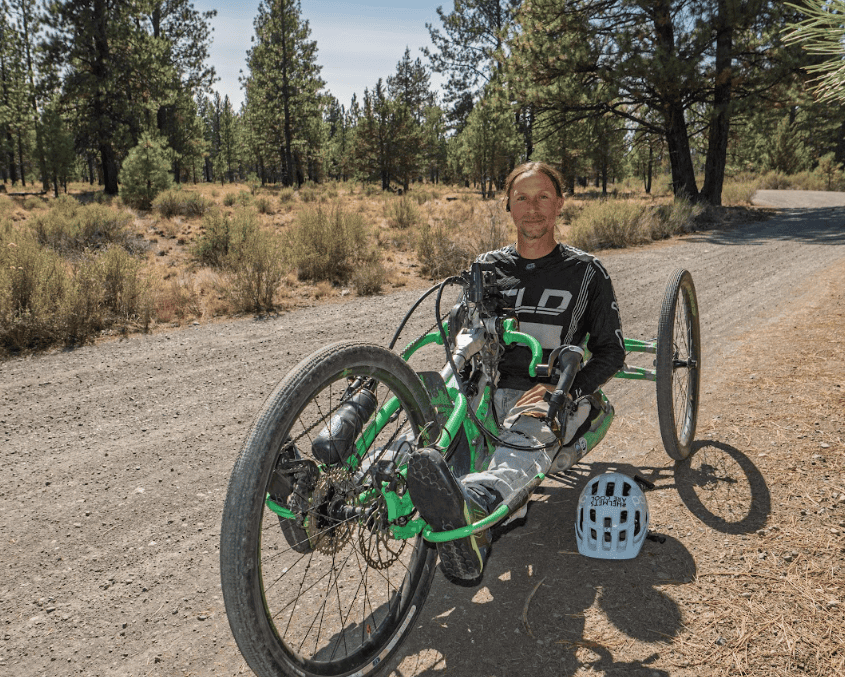
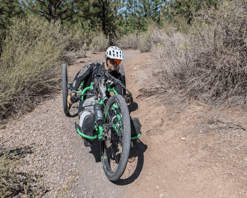
Skye Chaney has a thing for dirt. Mountain bike trails, gravel roads, remote landscapes—if there’s an opportunity to get outside and explore, he’s interested. And a spinal cord injury hasn’t changed that.
In October 2017, Skye was riding the famous Porcupine Rim trail in Moab, Utah, when he crashed over his handlebars. The accident left him with a spinal cord injury and unable to walk.
For someone who loved outdoor adventure, it was a life-changing moment. But Skye wasn’t ready to give up the places and experiences that meant so much to him.
He adapted a kayak. He learned to mono-ski. And with help from Craig Hospital in Colorado, he found his way back onto dirt with an adaptive mountain bike. And along the way, he discovered another way to explore the outdoors: Gravel cycling.
So, What Exactly is Gravel Cycling?
The answer is wonderfully simple: riding bikes on unpaved roads. Think quiet forest roads winding through the mountains. Old logging roads. Ranch roads crossing wide-open country. Desert tracks. Hard-packed dirt roads connecting tiny towns. Some gravel roads are smooth and fast. Others are rocky, sandy, steep, washboarded, or downright adventurous.
Unlike traditional mountain biking, gravel riding generally happens on roads rather than narrow singletrack. Unlike road cycling, you’re often far away from busy vehicle traffic. For adaptive cyclists, this can open up some great new possibilities.
Depending on the rider, the bike and the route, a gravel route can provide more room to maneuver than singletrack, fewer tight turns and technical obstacles, and an opportunity to get surprisingly deep into beautiful landscapes.
The Tricky Part: Finding the Right Route
Here’s where Skye’s experience becomes especially useful. Not all gravel is created equal. A route that looks perfectly manageable on a map might contain a locked gate, deep sand, a steep climb, a narrow passage, or a rocky section that changes everything for an adaptive cyclist. So the million dollar question before heading out the door is: :“Will this route work for me and my bike?”
Accessibility is incredibly personal. Different adaptive bikes have different widths, turning radiuses, ground clearances, traction, and capabilities. Riders have different strengths, abilities, comfort levels, and definitions of fun. So finding the right ride takes a little homework.
1. Start with a detailed Ride Guide
A line on a map isn’t enough. Look for a Ride Guide that provides information about distance, elevation, grades, road surfaces, technical difficulty, services, seasonal conditions, and potential obstacles.
For an adaptive cyclist, the details that other riders barely notice can sometimes determine whether a route works at all. Is there a gate you have to maneuver around? A narrow bridge? A rough section where ground clearance could be an issue? Is there adequate parking and room to unload your bike?
The more you know before you go, the fewer surprises you’ll encounter in the field. In Oregon, Skye uses Dirty Freehub to find and research gravel routes, he also posts his comments on the routes that he has reviewed.
2. Don’t judge a ride by mileage
A 10-mile ride can be considerably harder than a 25-mile ride. Look at total elevation gain and individual climbing grades, not just distance. As a rough starting point, 1,000 feet of climbing in 10 miles is significantly more demanding than 500 feet in 10 miles. And check the elevation profile—a route with 500 feet of climbing concentrated into one steep climb can feel very different from one where that elevation is spread throughout the ride.
Terrain matters just as much. Ten miles of smooth, hard-packed gravel can be easier than a few miles of loose rock, washboard, or sand. As you ride more, you’ll develop your own benchmarks for what works for you and your bike.
3. Find out what “gravel” really means
For an adaptive cyclist, surface conditions can have an even greater impact. Three wheels track differently than two, and depending on your bike, ruts, loose rock, sand, off-camber roads, water bars, mud, and low ground clearance can all become important considerations.
And don’t assume that a route labeled “gravel” stays on wide gravel roads. Some routes include doubletrack or singletrack that may be too narrow or technical for your bike. Know what your bike handles well, and look for routes that match it.
AI tools such as ChatGPT can be useful for doing some preliminary research. Be specific about your equipment. For example:
“I ride a recumbent adaptive trike with ___-inch-wide tires and ___ inches of ground clearance. Help me evaluate this route. Look for steep grades, rough surfaces, narrow trails, gates, bollards, closures, recent rider reports, weather and other potential obstacles.”
Treat that research as a starting point rather than a guarantee of accessibility. Conditions and access can change.
4. Research gates and barriers
A traditional cyclist may simply hop off the bike and squeeze around a gate, lift a bike over something, or walk through a narrow opening. That may not be possible with an adaptive bike. When researching a route, look specifically for:
- Gates and cattle guards
- Bollards and the width between them
- Narrow bridges
- Tight passages
- Stairs or large steps
- Downed trees
- Trail-width restrictions
- Places where a bike would need to be lifted or carried
Satellite imagery, photographs, Ride Guides, and recent rider reports can help identify potential barriers.
5. Learn to use navigation tools before the ride
Navigation isn’t just about following a route once you’re out there. Mapping tools can help you investigate a route before you ever leave home.
Apps such as Ride with GPS and Strava can help you examine elevation profiles, road types, satellite imagery, other cyclists’ routes, and heat maps. A heat map can tell you that lots of cyclists use a particular road or trail. That’s useful information, but it doesn’t mean the route is safe—or accessible for your particular bike.
Use mapping tools to look for:
- Steep climbs and descents
- Changes in road surface
- Narrow trails
- Alternate routes
- Bailout points
- Nearby paved roads
- Distance from services
- How remote the route becomes
Remember that mapping data isn’t always correct. A road shown as gravel might actually be primitive dirt, and something shown as a road may no longer be passable.
6. Read recent rider reports
Conditions change constantly. Trees fall. Roads wash out. Gates get locked. Logging operations begin. Snow lingers. Gravel gets freshly graded. Roads that were firm in June can become sandy or deeply rutted by August. Pay particular attention to comments mentioning sand, mud, ruts, washouts, downed trees, rough descents, gates and road closures.
And don’t be afraid to ask questions. A rider who was there last weekend may have exactly the information you need. Also, posting your route with your question in a local Facebook forum can be a great way to get information (For example, for routes in Oregon we have a facebook group called Riding Oregon Gravel which has 8,000 followers. Typically someone has just ridden the exact place you are looking to go!)
7. Ask other adaptive athletes
This may be one of your most valuable resources.Someone riding a similar adaptive bike may immediately recognize an issue that wouldn’t even occur to a traditional cyclist. Better yet, they may know routes that work particularly well with your equipment.
When asking for advice, describe your bike. A recumbent trike, handcycle, e-assist adaptive mountain bike, and high-clearance off-road trike can have very different capabilities.
Organizations such as the High Fives Foundation can also connect adaptive athletes and create opportunities to share experiences and knowledge.
8. Start with What You Already Know
Practice navigation on routes you already know. You’ll learn how what you see on the screen translates to what you encounter on the ground—and you’ll get comfortable following a route in a lower-risk environment. Choose something relatively short, with good road surfaces and easy turnaround options. Pay attention to how your bike—and your body—responds.
What grade becomes difficult? How does your bike handle washboard? What happens in loose gravel? How much battery do you use if you have e-assist? What surfaces are fun, and which ones turn the ride into work? Those experiences become your personal measuring stick for evaluating future routes. Pretty soon, you’ll be able to look at a route profile and think, “Yep, that’s my kind of ride.”
9. Create a Plan B
One of the joys of gravel is getting away from everything. That’s also one of its challenges. Cell service can disappear. Mechanical help may be miles away. Weather changes. A gate may be locked. A road may be considerably rougher than expected.
Before you ride, identify places where you can turn around, shorten the route, or return using an easier road.
If you’re concerned about a particular section, map your Plan B ahead of time and save it to your navigation device. Then, if something doesn’t work in the field, you can simply load the alternate route instead of trying to figure it out on the side of a remote gravel road.
Note: For remote adventures, also consider how you’ll communicate if you need help when there’s no cell service. Garmin Inreach with satellite communications can let you send and receive messages, when your phone isn’t working.
10. Find your version of adventure
This may be the most important one. One person’s perfect gravel ride is another person’s nightmare—and that has nothing to do with whether you’re an adaptive cyclist.
You don’t have to ride the longest route, conquer the steepest climb, or tackle the roughest terrain for it to count as an adventure. Maybe your perfect ride is 12 miles of smooth gravel along a river. Maybe it’s 40 miles through the high desert. Maybe you love climbing. Maybe you don’t. The goal is to find the kind of gravel adventure that makes you finish the ride already thinking about the next one.
Skye Would Like to Invite You to Oregon
Oregon is something of a gravel playground. There are forest roads through the Cascade Mountains, rolling farm roads, high-desert doubletrack, roads through old timber country, routes along the coast, and miles and miles of roads connecting small rural communities.
Dirty Freehub is an Oregon-based nonprofit that has spent years scouting and documenting these places.
Our free online Ride Guides include maps, elevation profiles, surface information, photographs, route descriptions, history, geology, points of interest, and information about potential challenges. And we’d like to make it especially easy for High Fives athletes to get started.
Want to Try Gravel? Your First Guidebook Is On Us.
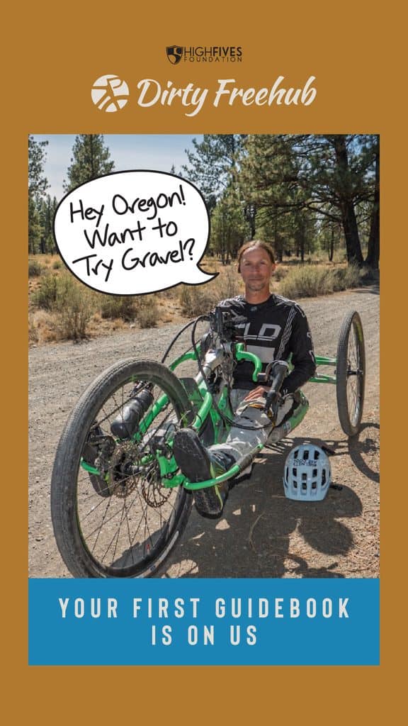
Dirty Freehub is offering High Fives Foundation readers a FREE printed Gravel Guide.
We publish pocket-sized guidebooks filled with routes, maps, artwork, local information, and ideas for your next adventure.
If you’re just getting started, we’d recommend choosing one of our All Access Gravel Guides. The All Access collection was developed around routes with more approachable characteristics. That can make these routes a good place to begin exploring what’s possible on gravel. You can choose from:
All Access Gravel Guide: Western Oregon
All Access Gravel Guide: Eastern Oregon
There are also Dirty Freehub gravel guides featuring other areas, including the Oregon Coast and Deschutes River Basin.
To get your free guide:
- Visit the Gravel Guides section at DirtyFreehub.org.
- Pick the guide you’d like.
- Enter code Skye at checkout.
About Skye Chaney
Skye Chaney is an adaptive cyclist based in Bend, Oregon, and a member of Dirty Freehub’s Gravel Champs program. Following a spinal cord injury in 2017, Skye returned to outdoor adventure through adaptive cycling, skiing, and kayaking. He has participated in adaptive cycling programs and events with the High Fives Foundation and continues to explore gravel and trails throughout Oregon and beyond.
Learn more:
Skye’s story: DirtyFreehub.org/gravel-champs/skye/
Free Ride Guides & Gravel Guidebooks: DirtyFreehub.org